The Ultimate Free Guide to New Zealand’s South Island 🇳🇿
Your 14+ day South Island itinerary, guide and digital map

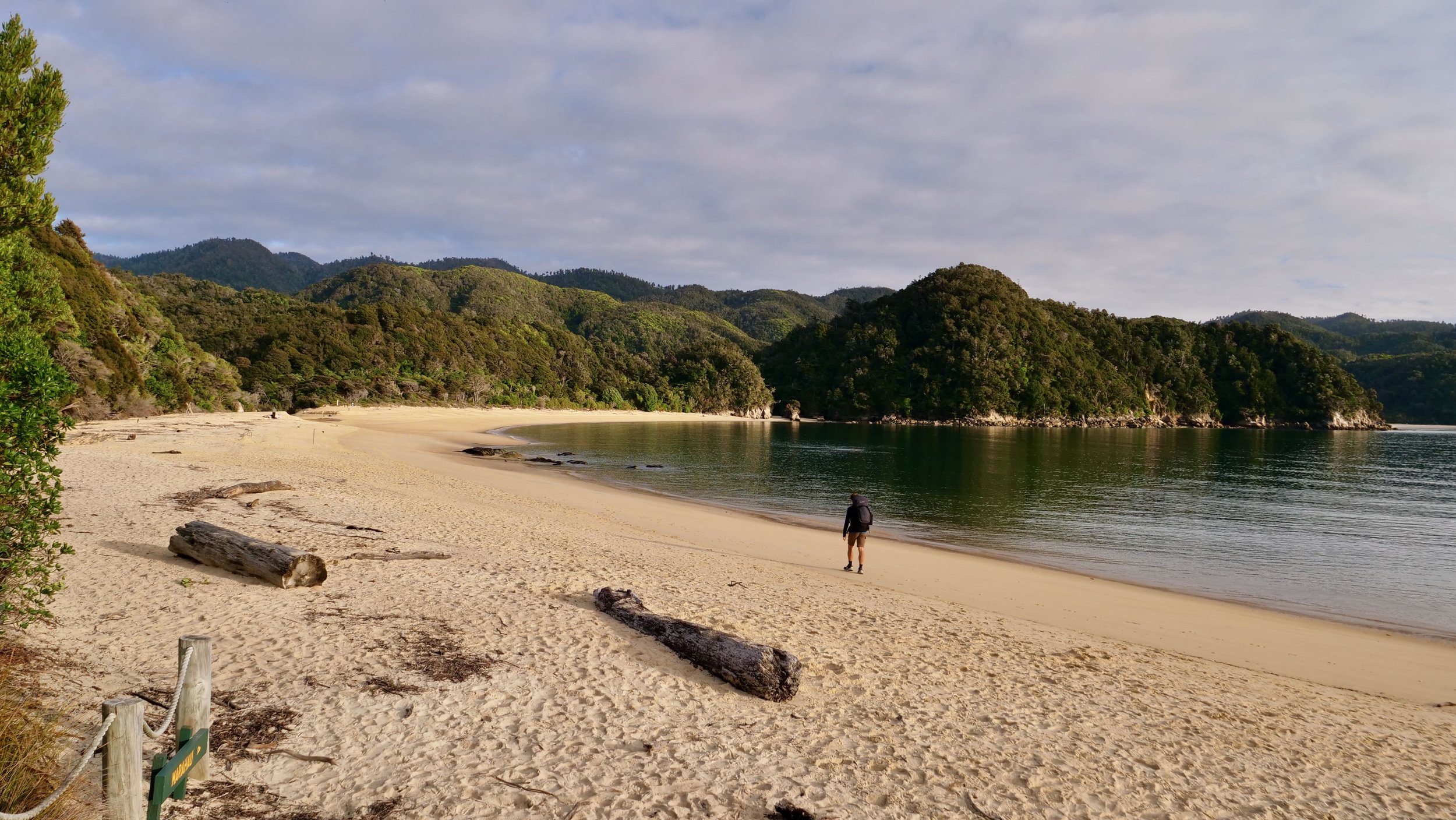
Me on the Abel Tasman hike
Hey, I’m Ross and welcome to my free South Island New Zealand guide.
I’ve travelled the South Island a few times now, and it honestly ranks as one of the best adventures I’ve ever done. On my most recent trip, I spent several weeks road-tripping the island in a car, covering thousands of kilometres from the rugged West Coast and Fiordland to the stunning Southern Alps and wild East Coast.
It was an unforgettable journey!
This detailed free guide, complete with a South Island itinerary and map, has everything you need to plan your own adventure. From top tips and must-see stops to places to eat, stay, and camp, I’ve also included what I’d do differently if I were to go again.
Planning your South Island trip can feel overwhelming at first, so I’ve broken this guide down into a simple, step-by-step structure to make your journey as smooth as possible.
Okay, lets get started with your adventure!
Planning your South Island itinerary
When planning your New Zealand South Island itinerary, it’s important to book accommodation (including campsites and holiday parks) in advance, especially during peak season (December to February). We travelled in spring, and while we could still find last-minute spots at hostels and holiday parks, many of the best campsites and hotels were already filling up fast.
If you’re travelling in a campervan, plan your overnight stops ahead of time. Popular freedom camping areas and holiday parks can fill up by late afternoon, particularly near Queenstown, Wanaka, and Fiordland.
It’s also worth noting that some popular attractions and activities (like Milford Sound cruises, glacier hikes, sky dives and scenic flights) often require pre-booking, so make sure you reserve in advance where possible.
One last tip, you will often find yourself without signal, so make sure to download this page as a PDF or save your maps for offline use. I’d also recommend getting a power bank to ensure you’ve got plenty of charge throughout, I use the USB-C 20,000 maH with 30W model (affiliate link). It charges my phone and Apple watch when wild camping and is a great lightweight option when on the go.
Now for the exciting part!
In addition to this free guide, here are a couple of handy resources to help you plan your perfect South Island trip:
Get my complete South Island travel guide featuring a 10–14 day itinerary, local tips, and insider recommendations — all in one easy-to-use PDF.
View digital guide →Explore the South Island in map form, complete with top hikes, scenic stops, food spots, fuel stations, and must-visit highlights — all designed to complement the 10–14 day itinerary.
View digital map →South Island New Zealand route map

New Zealand South Island map and route
We travelled the South Island in a loop starting and finishing in Christchurch, heading up the east coast before circling back down the wild west coast. Christchurch is often the best starting point thanks to its larger airport and cheaper car hire, though you could just as easily begin in Queenstown or Picton if arriving by ferry from the North Island.
This route saves the most dramatic scenery, Fiordland, the Southern Alps, and the West Coast glaciers, for later in the trip. If you have extra time, add side trips to Milford Sound, Mount Cook (Aoraki), and Abel Tasman National Park, which showcase some of the island’s most spectacular landscapes.
While it’s possible to see the South Island in just 7 days, it will feel rushed. Distances look short on the map, but winding roads mean journeys often take longer than expected. I’d recommend at least 10 to 18 days to experience the South Island at a comfortable pace.
You could skip regions if pressed for time, but every part of the South Island, from turquoise lakes and alpine passes to golden beaches and fjords, adds something unique to the journey.
Getting to Christchurch to start your South Island trip
By plane
Christchurch International Airport is the main gateway to the South Island, with direct flights from major New Zealand cities like Auckland and Wellington, as well as international connections from Australia, Asia, and beyond. From Auckland, the flight takes about 1 hour 20 minutes, and from Sydney around 3 hours.
By ferry & car
If you’re starting in the North Island, you can take the Interislander or Bluebridge ferry from Wellington to Picton (around 3.5 hours). From there, it’s a scenic 5–6 hour drive down the east coast to Christchurch, passing through Marlborough’s wine country and Kaikōura, famous for whale watching. The drive south from Picton is one of the most scenic in New Zealand, with coastal views and mountain backdrops almost the entire way.
By car
Christchurch is well connected by road, making it easy to reach by car or motorbike. Many travellers drive from Picton down State Highway 1, or loop across from Queenstown and the West Coast via the Southern Alps.
Car, campervan and motorhome hire
Hiring a campervan or motorhome is one of the most popular ways to explore the South Island, giving you the freedom to stay close to nature and change your plans as you go. There are plenty of companies to choose from, with pick-up and drop-off locations in Christchurch, Queenstown, and Picton. Some of the most popular include:
JUCY Rentals – budget-friendly vans with bright designs
Britz Campervans – wide range of options from 2–6 berth
Maui Motorhomes – premium large motorhomes, great for families
Apex Car Rentals – affordable cars and vans with flexible options
GO Rentals – reliable cars and campervans with good customer service
🚐 Ready to plan the rest of your South Island route?
Grab my South Island Guide featuring a 10–14 day itinerary, clear start/end points, and practical tips from real on-the-road experience — plus a free Google Map with 150+ pinned stops.
- ✅ Best places to visit, eat, and stay
- ✅ Car, campervan, and motorbike-friendly route notes
- ✅ Mobile & desktop PDF for easy on-the-go use
Accommodation on the South Island
Hotels, hostels, lodges, and luxury stays
From budget-friendly hostels and roadside motels to boutique lodges and luxury retreats, the South Island has no shortage of places to rest your head. Whether you’re travelling on a shoestring or looking to indulge in something special, you’ll find plenty of top-rated stays to suit every kind of traveller.
Campsites, holiday parks, and campervan stays
If you’re exploring by campervan, you’ll be spoiled for choice with holiday parks, campsites, and freedom camping areas across the island. We used the apps CamperMate and Rankers Camping NZ to find spots both are packed with user reviews, facilities, and prices. Just keep in mind that popular sites often fill up by late afternoon during peak season.
14 day New Zealand South Island itinerary & map
This 14-day South Island road trip starts and ends in Christchurch, taking you through Kaikōura, Marlborough, Abel Tasman, the wild West Coast, Wānaka, Queenstown, Milford Sound, Tekapo, and back again. It’s the perfect loop to experience New Zealand’s dramatic landscapes, from turquoise lakes and fjords to glaciers and golden beaches. While 14 days is suggested, you can easily extend your stays at each location if you want to include more activities or multi-day hikes. These are highlighted below.
Distances on the map might look short, but South Island driving is often slow due to winding roads and scenic stops. This itinerary gives you a balance of drive days and rest days so you can enjoy the journey without feeling rushed.
The day-by-day breakdown
Day 1: Christchurch to Kaikōura
Estimated journey time: 180 km / 2.5–3 hrs

Day 1 driving route
Your South Island adventure begins in Christchurch, the largest city in the region and an easy hub for car or campervan hire. Heading north along State Highway 1, the road hugs the dramatic Pacific coastline, offering endless viewpoints of the ocean and rugged cliffs.
Kaikōura is world-famous for its marine life. This is one of the best places on earth to spot sperm whales, orcas, and dusky dolphins, with boat tours running daily.
You can also swim with wild dolphins or take a scenic flight for an aerial view of the coastline. Don’t leave without trying the local specialty, freshly caught crayfish, which Kaikōura literally translates to.
-
Ohau Point Seal Colony – see fur seals lounging on the rocks right by the roadside.
Kaikōura Whale Watching Tour – one of the world’s best spots for seeing sperm whales year-round.
Kaikōura Peninsula Walkway – coastal track with sweeping ocean and mountain views.
-
Luxury – The White Morph Heritage Collection
A stunning beachfront property with spacious ocean-view rooms and private balconies. Located right on the Esplanade, it’s within easy walking distance of cafés, restaurants, and the seal colony walk. Perfect for travellers wanting comfort and sea views.Mid-range – Kaikōura Boutique Hotel
A stylish, contemporary boutique stay with beautifully designed rooms and a warm, personal atmosphere. Just across the road from the beach, this spot blends coastal charm with modern comfort — ideal for couples.Budget – Kaikōura TOP 10 Holiday Park
Excellent for campervans, families, or travellers on a budget. Offers powered sites, cabins, and motel-style rooms with clean facilities, a communal kitchen, and a pool. Centrally located and great value. -
⚡️ This part of the guide is exclusive content!
To unlock the full itinerary, detailed map, and my top local tips, you’ll need the full South Island Guide.👉 Get access here.
-
⚡️ This part of the guide is exclusive content!
To unlock the full itinerary, detailed map, and my top local tips, you’ll need the full South Island Guide.👉 Get access here.
-
⚡️ This part of the guide is exclusive content!
To unlock the full itinerary, detailed map, and my top local tips, you’ll need the full South Island Guide.👉 Get access here.

Kaikoura is one of the best places to spot whales
Top tips for day 1 on the South Island
Book your Kaikōura whale watching tour in advance, as spaces sell out quickly in peak season.
Stop at the Ohau Point Seal Colony on the way north, it’s one of the best free wildlife stops on the South Island.
Try local crayfish at a roadside stall or restaurant; it’s what Kaikōura is most famous for.
Day 2: Kaikōura to Blenheim
Estimated journey time: 130 km / 1.5–2.5 hrs

Day 2 driving route
From Kaikōura, continue north into Marlborough, New Zealand’s largest wine region. The short drive to Blenheim is easy and scenic, passing rolling vineyards and sunny valleys.
Blenheim is the ideal base for a wine tour, this is the home of world-class Sauvignon Blanc, with over 100 wineries in the region. You can cycle between vineyards, book a guided tour, or simply relax at a cellar door with a platter and a glass of crisp white.
Beyond wine, Blenheim also has walking trails, the Omaka Aviation Heritage Centre, and local farmers’ markets.
-
Marlborough Wineries – cycle or tour through world-class Sauvignon Blanc vineyards.
Omaka Aviation Heritage Centre – historic aircraft displays curated by Peter Jackson.
Wither Hills Farm Park – walking and biking tracks with panoramic views over Blenheim.
-
Luxury – The Marlborough Lodge
A restored heritage building set within 16 acres of gardens and vineyards. Think elegant rooms, fine dining, and a peaceful country setting just outside Blenheim.Mid-range – Chateau Marlborough
A modern boutique hotel close to the town centre, offering stylish rooms, a pool, and an on-site restaurant. Perfect for comfort without the splurge.
Click to find out moreBudget – Blenheim Bridges Holiday Park
Great for road trippers, this park offers cabins, powered sites, and easy access to the river and local wineries.
Click to find out more -
⚡️ This part of the guide is exclusive content!
To unlock the full itinerary, detailed map, and my top local tips, you’ll need the full South Island Guide.👉 Get access here.
-
⚡️ This part of the guide is exclusive content!
To unlock the full itinerary, detailed map, and my top local tips, you’ll need the full South Island Guide.👉 Get access here.
-
⚡️ This part of the guide is exclusive content!
To unlock the full itinerary, detailed map, and my top local tips, you’ll need the full South Island Guide.👉 Get access here.
Top tips
Leave early so you can maximise your afternoon with a Marlborough wine tour.
If you’re driving, consider a guided cycling wine trail, Blenheim has flat, easy routes between vineyards.
Don’t just stick to Sauvignon Blanc; try Chardonnay and Pinot Noir, which also thrive in the region.

🌄 Planning your South Island road trip?
Whether you’re chasing mountain views, coastal drives, or hidden local gems, my South Island Guide has you covered with a 10–14 day itinerary, clear route notes, and insider tips from real adventures on the road.
Want something more tailored? I also offer a custom itinerary service where I’ll plan your full trip based on your route, interests, and travel style.
- ✅ 10–14 day route with clear start and end points
- ✅ Best places to visit, stay, and explore
- ✅ Mobile & desktop PDF + free interactive map
Day 3: Blenheim to Kaiteriteri (Abel Tasman)
Estimated journey time: 195 km / 3 – 4 hrs
Today’s drive takes you west to Kaiteriteri, the gateway to Abel Tasman National Park. Famous for its golden sandy beaches, turquoise waters, and coastal hiking tracks, Abel Tasman is one of the most popular national parks in New Zealand.

Day 3 driving route
But before you get there, head north to the harbour town of Picton and join the spectacular Queen Charlotte Drive, a twisting coastal road with incredible views over the Marlborough Sounds. Along the way, you can stop at several viewpoints, including the Cullen Point Lookout, or take the short Governors Bay Track, which descends to a secluded sandy beach.
Back on the road, stop in the town of Richmond to refuel and grab lunch before continuing to Kaiteriteri.
Kaiteriteri itself is a charming seaside town with sweeping views of the sea and mountains, making it the perfect base for exploring Abel Tasman. From here, you can take a water taxi into the park, hire a kayak to paddle through hidden coves, or enjoy shorter walks along the Abel Tasman Coast Track.
Day 3: Places to explore and visit
Kaiteriteri Beach – golden sands and crystal-clear water, perfect for swimming.
Abel Tasman Coast Track – one of New Zealand’s Great Walks, with water taxis to trailheads.
Split Apple Rock – a famous natural rock formation just offshore.
Top tips for day 3 on the South Island
Kaiteriteri Beach is one of the safest swimming beaches in New Zealand, perfect for a quick dip after your drive.
Book a water taxi into Abel Tasman National Park in advance if you want to hike or kayak part of the Coast Track.
Pack insect repellent, sandflies are common around the beaches and estuaries.
Where to stay in Kaiteriteri
Luxury – Split Apple Retreat
A high-end wellness retreat perched above the coast between Kaiteriteri and Marahau. Stunning views, private suites, and a focus on relaxation, food, and mindfulness. Perfect for a splurge night or special occasion.
Mid-range – Kaiteriteri Reserve Apartments
Modern apartments overlooking the beach, right in the heart of Kaiteriteri. Ideal for easy access to the water taxis, cafés, and walking tracks.
Budget – Kaiteriteri Recreation Reserve Campground
A fantastic beachfront campground with powered sites, cabins, and direct access to the sand. Book early in peak season — it’s one of the most popular spots in the South Island.
Optional: Abel Tasman Great Walk
🥾 Add 3–4 days here to complete the full Abel Tasman Great Walk, one of New Zealand’s 10 official Great Walks, offering a multi-day coastal adventure with overnight huts and campsites. This was my favourite great walk with the most beautiful scenery.
You can read more about my Abel Tasman great walk adventure here or watch my full youtube video here.
⚡ Quick South Island Travel Tip
Mobile phone signal across New Zealand’s South Island can be patchy, especially on the West Coast, in Fiordland, and around mountain passes. Make sure to download the offline map for the South Island on Google Maps so you’re never caught out without directions.
I’d also recommend carrying a reliable power bank to keep your devices charged on long drives and hikes. I use the USB-C 20,000mAh with 30W model , and it’s been a lifesaver on the road.
Day 4: Kaiteriteri to Punakaiki
Estimated journey time: 350 km / 5 – 6 hrs
This is one of the longer drive days, but also one of the most rewarding. The road winds through Nelson Lakes National Park and the scenic Buller Gorge, with plenty of opportunities to stop for short walks, river viewpoints, and suspension bridges.
Your first recommended stop is Lake Rotoiti, where the long wooden jetty frames incredible views across the lake towards snow-dusted peaks, it’s a classic South Island photo spot.
Continue on to Buller Gorge, where you can stretch your legs on New Zealand’s longest swing bridge or take a quick riverside walk.
A little further along the coast, detour to Cape Foulwind, home to a fur seal colony. From the lookout, you’ll often spot dozens of seals basking on the rocks or playing in the surf below.
Your final destination, Punakaiki, is famous for the otherworldly Pancake Rocks and Blowholes, a unique limestone formation where layered rock stacks resemble piles of pancakes. Visit at high tide for the most dramatic blowhole action, when seawater surges through the rock formations like natural geysers.
When booking accommodation, keep in mind that options in Punakaiki are limited. If nothing is available, consider staying in Westport, a short drive away, and ticking off Pancake Rocks the following day.

Day 4 driving route

Day 4 key stops
Day 4: Places to visit and explore
Nelson Lakes National Park – stop at Lake Rotoiti for classic jetty views of the mountains.
Buller Gorge – scenic river gorge with swing bridges and short trails.
Punakaiki Pancake Rocks & Blowholes – unique layered limestone formations on the coast.
-
Luxury – Punakaiki Resort
Set right on the coast, this eco-friendly resort offers rooms with ocean views just a short walk from Pancake Rocks. Ideal for catching sunset or sunrise over the Tasman Sea.Mid-range – Hydrangea Cottages
Charming, self-contained cottages surrounded by native bush, just minutes from the beach. Great for couples looking for a peaceful, private stay.Budget – Punakaiki Beach Camp
A relaxed beachfront campsite with powered sites, cabins, and a friendly atmosphere. Perfect for campervans or those travelling on a budget. -
⚡️ This part of the guide is exclusive content!
To unlock the full itinerary, detailed map, and my top local tips, you’ll need the full South Island Guide.👉 Get access here.
-
⚡️ This part of the guide is exclusive content!
To unlock the full itinerary, detailed map, and my top local tips, you’ll need the full South Island Guide.👉 Get access here.
-
⚡️ This part of the guide is exclusive content!
To unlock the full itinerary, detailed map, and my top local tips, you’ll need the full South Island Guide.👉 Get access here.
Top tips for day four
Stop in Nelson Lakes National Park for a short walk at Lake Rotoiti or Lake Rotoroa.
Plan to visit the Punakaiki Pancake Rocks at high tide to see the blowholes in action.
There are limited petrol stations on the West Coast, so top up your tank before leaving Nelson.
Day 5: Punakaiki to Hokitika
Estimated journey time: 150 km / 2 - 2.5 hrs
Today is a shorter drive down the West Coast, giving you plenty of time to explore along the way. Begin your morning with a visit to the Pancake Rocks and Blowholes in Punakaiki, where seawater surges dramatically through the layered limestone formations.
From there, follow the coast south towards Hokitika. Along the way, it’s worth taking a short break in Greymouth, the largest town on the West Coast. Here you’ll find cafés, fuel stations, local shops, and even a museum if you’d like to stretch your legs and learn about the region’s gold-mining past.
The highlight of the day is the spectacular Hokitika Gorge, famous for its bright turquoise waters, lush rainforest, and swing bridge crossing. It’s one of the most photographed spots on the South Island, and for good reason.
Hokitika itself is also known as the greenstone (pounamu) capital of New Zealand, making it a great place to pick up authentic jewellery or carvings created by local artisans.

Day 5 key places

Day 5 route
Day 5: Places to visit and explore
Hokitika Gorge – bright turquoise waters surrounded by lush native bush.
Hokitika Beach – driftwood-covered beach, famous for sunsets and the “Hokitika” sign.
Local Greenstone Carvers – learn about Māori pounamu and buy jewellery from local artisans.
-
Luxury – Rimu Lodge
A boutique luxury lodge set in native bush overlooking the Hokitika River Valley. Spacious rooms, stunning views, and a peaceful atmosphere just a short drive from town.Mid-range – Beachfront Hotel Hokitika
Located right on the beach, this hotel offers modern rooms with sea views and an on-site restaurant. Perfect for catching the sunset without even leaving your room.Budget – Hokitika Holiday Park
Friendly and well-equipped with powered sites, cabins, and communal facilities. A great option for campervans or those travelling on a budget. -
⚡️ This part of the guide is exclusive content!
To unlock the full itinerary, detailed map, and my top local tips, you’ll need the full South Island Guide.👉 Get access here.
-
⚡️ This part of the guide is exclusive content!
To unlock the full itinerary, detailed map, and my top local tips, you’ll need the full South Island Guide.👉 Get access here.
Top tips for day 5
Arrive in Hokitika early to visit the Hokitika Gorge, which is best seen in full daylight.
Walk Hokitika Beach at sunset for iconic driftwood photography.
Hokitika is the pounamu (greenstone) capital of New Zealand — buy a locally carved piece as a keepsake.
Day 6: Hokitika to Franz Josef
Estimated journey time: 135 km / 2.5 hrs
Leaving Hokitika, the drive south along the wild West Coast is nothing short of spectacular. The road twists between rugged coastline, dense rainforest, and towering mountain backdrops, with plenty of chances to stop and soak in the views. On the way, make a short detour to the small village of Ōkārito, a peaceful coastal settlement known for its cosy coffee stop and the stunning Ōkārito Lagoon, New Zealand’s largest wetland and a sanctuary for birdlife, including the rare white heron.
From there, it’s only a short drive to Franz Josef village, a lively hub and gateway to one of the South Island’s most iconic natural wonders. This is one of the few places in the world where glaciers descend almost to sea level, making them some of the most accessible anywhere.
Franz Josef offers the perfect blend of adventure and relaxation. Lace up your boots for a short walk to the glacier viewpoint, or take to the skies for a heli-hike or scenic flight. For something more low-key, the nearby lakes and wetlands are ideal for kayaking or birdwatching. There’s no shortage of activities here, but it’s important to note that the weather in Franz Josef is highly unpredictable, heli-hikes are frequently cancelled, sometimes even at the very last minute, just as the helicopter is about to lift off.
On my visit, I managed to complete several local hikes, many start off steep but reward you quickly with panoramic views (as long as the clouds haven’t rolled in). I was also fortunate to catch a perfect weather window for a heli-hike, and it was an experience I’ll never forget. Taking off from Franz Josef, soaring over the Southern Alps, then landing high on the glacier to walk through an ice cave and under frozen arches felt truly surreal.
A quick note: tomorrow is a rest day in Franz Josef, which is handy if poor weather forces you to reschedule an activity. After that, you’ll continue south on a long but breathtaking drive to Wānaka, with an essential early morning stop at Lake Matheson, one of the best sunrise spots in New Zealand.

Day 6 key stops

Day 6 driving route
Best places to visit in Franz Josef:
Lake Mapourika – a calm lake ideal for kayaking with mirrored reflections of the Southern Alps.
Okarito Lagoon – New Zealand’s largest wetland, home to rare white herons and other birdlife.
Top tips:
Book heli-hikes or scenic flights in advance they often sell out and are weather-dependent.
If a flight is cancelled, the valley walk still gives excellent glacier views for free.
🏡 Where to stay in Franz Josef
Luxury – Te Waonui Forest Retreat
A luxurious eco-lodge set among native bush, offering fine dining, spacious rooms, and exceptional service. Perfect for a peaceful retreat surrounded by nature.
Mid-range – Rainforest Retreat
Tucked into lush greenery, this popular lodge has everything from private treehouses to cosy cabins. It’s central, atmospheric, and comes with a great on-site restaurant and bar.
Budget – Chateau Backpackers & Motels
Friendly, affordable, and located right in the village centre. Offers private and dorm rooms, communal kitchen, and free soup in the evenings — a West Coast classic.
Day 7: Franz Josef (rest/ activity day)
A rest day in Franz Josef gives you time to fully enjoy the area without rushing. The town itself has plenty of cafés and restaurants, but the real draw is the surrounding wilderness. With both Franz Josef and Fox Glacier nearby, you can spend the day exploring alpine valleys, shimmering lakes, and rainforest tracks.
If you’re up for an early start, Lake Matheson is the best place to catch sunrise reflections of Aoraki/Mount Cook, New Zealand’s tallest mountain. Wildlife enthusiasts will love visiting the West Coast Wildlife Centre, where you can see the rare rowi kiwi, a species only found in this region.
Best places to visit on day 7:
Fox Glacier – a quieter alternative to Franz Josef, just 30 minutes south.
Lake Matheson – famous for postcard-perfect reflections at sunrise. I suggest doing this tomorrow, on your journey south. This is my favourite place in the whole of New Zealand and you’ll see why from the photo below.
West Coast Wildlife Centre – a conservation hub with rare kiwi viewing.
Walks/ Hikes from Franz Josef:
Sentinel Rock short walk
Canavans Knob short walk
Tatare Tunnels short walk
Alex Knob long walk
Robert's Point long walk
Lake Wombat walk
Top tips for day 7 on New Zealands south Island road trip:
If you didn’t manage a heli-hike yesterday, use today as a backup in case of cancellations.
Franz Josef and Fox Glaciers are shrinking — see them while you can.
Day 8: Franz Josef to Wānaka
Estimated journey time: 285 km / 5 – 6 hrs
Today’s drive is one of the true highlights of the South Island. Heading south from Franz Josef, your first stop should be the stunning Lake Matheson. Arrive early in the morning for the best chance to see perfect mirror-like reflections of Mount Cook and Mount Tasman on the lake’s surface, it’s one of the most photographed views in New Zealand.
Continuing down the West Coast, there are several unmissable stops along the way. Ship Creek offers a short boardwalk through coastal forest and dunes, while both Thunder Creek Falls and Fantail Falls provide spectacular roadside waterfall walks, each with its own unique character. Just before reaching the Haast Pass, you’ll find a final chance to refuel at Johnston Motors, as services become limited once you begin the alpine crossing.
The road then passes through the small township of Haast before climbing over the Haast Pass, a dramatic alpine route lined with cascading waterfalls, deep gorges, and lush rainforest. As you cross into Otago, the scenery changes dramatically, wide valleys, tussock-covered hills, and bright turquoise rivers lead the way to your destination, the beautiful lakeside town of Wānaka.
The drive itself feels like an adventure, with each stop adding to the experience. From the waterfalls to the famous Blue Pools Track, all easily accessible from the highway, the route is packed with natural beauty. By the time you arrive in Wānaka, you’ll see why this journey is often described as one of the most scenic drives in New Zealand.

Day 8 key stops

Day 8 driving route
Best places to visit in Wanaka
Lake Matheson – world-famous for its sunrise reflections of Mount Cook and Mount Tasman. It’s my favourite place in all of New Zealand, and when you see the mirror-like water at dawn, you’ll understand why. The short loop track is peaceful and easy, with incredible viewpoints along the way.
By the car park, there’s a cosy café serving excellent coffee, hearty breakfasts, and lunches, plus a gift shop with local crafts, the perfect stop before or after your walk.
Thunder Creek & Fantail Falls – short waterfall walks along Haast Pass.
Blue Pools Track – a suspension bridge and glacier-fed pools with striking blue water.
Lake Wānaka – relax on the lakefront after your drive.
Top tips for day 8:
Set off extra early and go to Lake Matheson at dawn for the best chance of clear reflections.
Allow extra time for stops as this is a drive to savour.
Services are limited along Haast Pass, so fuel up and bring snacks before leaving Franz Josef.
The Blue Pools can be cold, but they’re perfect for a refreshing dip in summer.
🏡 Day 8: Where to stay in Wānaka
Luxury – Edgewater Hotel
A lakeside retreat with panoramic mountain views, spa facilities, and a short walk to town. Ideal for unwinding after a long day on the road.
Mid-range – Wanaka View Motel
Comfortable studios and apartments overlooking Lake Wānaka. Great location, friendly hosts, and easy walking distance to cafés and shops.
Budget – Wanaka Backpackers Bothy
Popular among travellers for its social vibe and clean facilities. Shared kitchen, cosy lounge, and mountain views — perfect for budget-conscious adventurers.
Day 9: Wānaka (rest day)
Wānaka is a small lakeside town with a laid-back vibe, making it a perfect place to slow down.
If you’re keen to get out hiking, there are number of short walk or hike options. Roy’s Peak Track is the most popular, leading to a viewpoint overlooking Lake Wānaka and surrounding peaks. For a quieter alternative, try Isthmus Peak, which offers equally stunning vistas but with fewer people.
One of the most iconic sights is the Wānaka Tree, a solitary willow growing out of the water that has become one of New Zealand’s most photographed landmarks.
Wine lovers can also visit nearby vineyards such as Rippon, which combines tastings with stunning lake views.
Best places to visit in Wānaka:
Wānaka Tree – an Instagram-famous photo spot.
Rippon Vineyard – known for free tastings and scenic views.
Walks and hikes from Wānaka:
Roy’s Peak
Isthmus
Top tips:
Roy’s Peak is extremely popular — start early to beat the crowds.
Visit Wānaka Tree at sunrise for beautiful colours and fewer crowds.
Isthmus Peak requires less queueing for photos but is just as scenic.
Rippon Vineyard is one of the most scenic wineries in the world, don’t miss it.
🏕️ Ready to explore the South Island like a pro?
My New Zealand South Island Guide makes planning easy — with a 10–14 day itinerary, local tips, and detailed routes covering everything from mountain passes to coastal drives.
Here’s what you’ll get:
- ✅ A 10–14 day itinerary with clear start and end points
- ✅ The best places to visit, eat, and stay across the South Island
- ✅ Car, campervan, and motorbike-friendly roads and stops
- ✅ Mobile & desktop PDF for easy use while travelling
- 🗺️ Free interactive Google Map with 150+ pinned locations
- 🧭 Prefer something unique? I can build a personalised South Island itinerary tailored to your route, interests, and pace.
Day 10: Wānaka (rest day/ activity day)
Spend today enjoying the lakefront, browsing boutique shops, and trying out local café.
Wānaka has plenty of other attractions. The quirky Puzzling World is fun for all ages, while the Wānaka Lavender Farm is a beautiful place to relax, especially when the lavender is in bloom during summer.
Day 11: Wānaka to Queenstown (via Arrowtown)
Estimated journey time: 75 km / 1.5 hrs
This short but scenic drive takes you to Queenstown, the adventure capital of New Zealand. On the way, stop at the historic village of Arrowtown, a beautifully preserved former gold-mining town. Its tree-lined streets are particularly stunning in autumn when the leaves turn golden.
Queenstown itself is a buzzing town set on the shores of Lake Wakatipu, surrounded by dramatic mountains. It’s packed with adrenaline activities, but it also offers world-class dining, wineries, and scenic lookouts.

Day 11 Key stops

Day 11 Map
Best places to visit on day 11:
Arrowtown – charming gold-mining heritage and autumn colours.
Kawarau Gorge Suspension Bridge – home of the world’s first bungy jump.
Lake Wakatipu viewpoints – roadside stops with stunning alpine vistas.
Top tips for day 11:
Spend at least a few hours in Arrowtown to soak up the atmosphere. There is plenty to see and do plus a number of short walks to explore.
Try a Fergburger when you reach Queenstown, it’s world-famous but there is often a line throughout the day
Campervans should park outside the busy town centre and walk in as space is limited.
Where to stay in Queenstown, New Zealand
Whether you’re looking for a luxury retreat, a cosy lodge, or budget-friendly backpacker accommodation, Queenstown has something for every traveller.
Luxury Hotels & Boutique Stays in Queenstown
Swiss-Belsuites Pounamu Queenstown – Iconic and luxurious, right on the waterfront.
Azur Lodge – Private villas with incredible lake views, perfect for couples.
The Rees Hotel – A 5-star hotel with spacious apartments and a private jetty on Lake Wakatipu.
Mid-range Hotels & Guesthouses in Queenstown
Queenstown Park Boutique Hotel – Modern and stylish, with great service and mountain views.
The Dairy Private Hotel – A charming boutique stay in the centre of town.
Kamana Lakehouse – Cosy yet modern, with some of the best views over the lake.
Budget & Backpacker options in Queenstown
Nomads Queenstown – A lively hostel in the town centre, great for social travellers.
YHA Queenstown Central – Affordable and conveniently located.
Adventure Queenstown Hostel – Popular with solo travellers and backpackers.
Day 12: Queenstown (rest day)
Queenstown is often called the adventure capital of the world. Whether you’re into bungy jumping, skydiving, or jet boating, this is the place to do it. If adrenaline isn’t your thing, Queenstown also offers relaxing alternatives like lake cruises, wine tours, and scenic gondola rides.
The Skyline Gondola is a must-do, taking you up Bob’s Peak for sweeping views over the town and Lake Wakatipu. Milford Sound can also be visited as a long day trip or overnight excursion, and it’s one of the most breathtaking natural wonders in New Zealand.
For a more detailed guide on what to do and see in and around Queenstown, checkout my full Queenstown guide here:
Best places to visit:
Skyline Gondola – gondola ride to epic views.
Shotover Jet – thrilling jet boat through narrow canyons.
Milford Sound (optional trip) – fjord cruise or scenic flight.
Top tips:
Book adventure activities in advance, especially in peak season.
The gondola offers luge rides at the top — fun for all ages.
Milford Sound is a long trip by road, so consider a scenic flight if budget allows.
Day 13: Queenstown to Tekapo
Estimated time: 255 km / 3.5–4.5 hrs

Map of the route between Queenstown and Tekapo
Leaving Queenstown, the drive north through Lindis Pass is a highlight in itself, with rolling golden hills and dramatic alpine scenery. The journey then takes you past Lake Pukaki, where the glacier-fed water is a dazzling shade of turquoise, and on clear days, you’ll see Aoraki/Mount Cook towering in the distance.
Your destination, Lake Tekapo, is famous for its picture-perfect Church of the Good Shepherd and as one of the world’s top stargazing spots within the Aoraki Mackenzie Dark Sky Reserve.
Best places to visit:
Lindis Pass – scenic alpine drive.
Lake Pukaki – iconic views of Mount Cook.
Church of the Good Shepherd – one of New Zealand’s most photographed churches.
Top tips:
Stop at Lake Pukaki for incredible photo opportunities.
Visit the Church of the Good Shepherd at sunrise or sunset to avoid crowds.
Book a stargazing tour at Mount John Observatory for the ultimate night-sky experience.
🏡 Day 14: Where to stay in Tekapo
Luxury – Galaxy Boutique Hotel
Modern, elegant rooms with lake views and balconies — perfect for watching the stars from the comfort of your bed.
Mid-range – Peppers Bluewater Resort
Stylish apartments overlooking Lake Tekapo, within walking distance of restaurants, cafés, and the Church of the Good Shepherd.
Budget – Tailor-Made Tekapo Backpackers
A cosy, friendly hostel with clean rooms, communal kitchen, and great social spaces. Excellent location close to the lake.
Day 14: Tekapo to Christchurch
Estimated journey time: 225 km / 2.5–3 hrs
The final leg of your journey takes you back to Christchurch across the Canterbury Plains. This drive is more relaxed, giving you time to reflect on your South Island adventure. Along the way, you can stop in small towns like Geraldine, known for its artisan foods, bakeries, and boutique shops.

Map of final day in New Zealand Lake Tekapo to Christchurch
Back in Christchurch, take a stroll through the Botanic Gardens, explore the city’s vibrant street art, or enjoy a relaxing evening by the Avon River.
Best places to visit:
Mount John Observatory – even if you didn’t stargaze, it’s worth a daytime visit.
Geraldine – charming stop with artisan treats.
Christchurch Botanic Gardens – a peaceful end to your trip.
Top tips:
Break up the drive with a coffee stop in Geraldine.
Explore Christchurch’s central city if you have time before your flight.
Return your rental car early to avoid late fees.
✨ For the full list of attractions, hidden spots, and a detailed interactive map, check out my complete New Zealand South Island Guide and map here.
🏡 Day 15: Where to stay in Christchurch
Luxury – The George
Boutique five-star hotel overlooking Hagley Park, known for exceptional service and comfort. A peaceful retreat within walking distance of the city centre.
Mid-range – Hotel 115
Modern, stylish, and central — located right beside Christchurch’s historic tram route. Ideal for short stays before or after a flight.
Budget – Urbanz Hostel
Clean, sociable, and affordable. Great facilities, friendly staff, and walking distance to all the main attractions.
FAQs
What is the best month to visit the South Island, New Zealand?
The best month to visit New Zealand’s South Island is generally February or March. The summer crowds have eased, the weather is still warm, and conditions are perfect for hiking, road trips, and outdoor activities. Spring (October–November) is also beautiful, with wildflowers, snow-capped peaks, and fewer tourists, though the weather can be more unpredictable.
When is the best time to visit New Zealand?
The best time to visit New Zealand depends on the experience you want:
Summer (December–February): Warmest weather, long days, and busiest tourist season.
Autumn (March–May): Cooler, stable conditions with fewer crowds and beautiful autumn colours.
Winter (June–August): Best for skiing and snowboarding around Queenstown and Wānaka.
Spring (September–November): Quieter, with fresh blooms and powerful waterfalls, though changeable weather.
What is mobile phone signal like in New Zealand?
Mobile phone coverage in New Zealand is good in cities and larger towns, but it can be patchy or non-existent in remote areas such as Fiordland, the West Coast, and mountain passes. Expect reliable 4G in most populated areas, 5G in larger cities, and very little service in wilderness regions. It’s worth downloading offline maps and carrying a power bank if you’re planning long hikes or remote road trips.
Is it better to do the South Island clockwise or anticlockwise?
There’s no wrong way to explore the South Island, but many travellers prefer going anticlockwise from Christchurch. This means heading up the east coast to Kaikōura and Marlborough first, then across to Abel Tasman before looping down the wild West Coast and through the Southern Alps. By saving Fiordland, Wānaka, and Queenstown for later in your trip, you finish on a real high with some of the island’s most dramatic scenery.
Where is the best place to start a South Island trip?
Most visitors start in Christchurch, which has the largest airport and is ideal for a full loop. If you’re arriving by ferry from the North Island, Picton is the natural starting point. For shorter trips focused on adventure activities, Queenstown makes a great base, with direct flights from many cities.
How long do you need on each island?
To make the most of your time in New Zealand without rushing, plan for at least two weeks on each island, so a month in total. On the North Island, highlights include Auckland, Rotorua, and Wellington. On the South Island, must-see spots are Queenstown, Wānaka, Christchurch, Fiordland, and the West Coast.
I recently spent three months travelling New Zealand, including both islands, and even did the South Island twice, once on the Kiwi bus and once by car. The itineraries in this guide are designed to be realistic for annual leave trips, but you can easily adapt them to longer journeys if you’ve got more time.
Read my other New Zealand guides and resources
New Zealand South Island
〰️〰️
New Zealand South Island 〰️〰️
Discover the best things to do in Queenstown, New Zealand — from lake cruises and epic hikes to where to eat and stay. Explore my free Queenstown travel guide, then grab the full New Zealand Guide and Interactive Map with 100+ pinned locations to plan your trip with ease.